
City Council in brief: City accepts $7.5 million to improve dangerous Rte. 20 interchange
Mayor Jeannette A. McCarthy asked city councilors this week to accept $7.5 million in state grants to construct a new stretch of road in Waltham just west of I-95.
At a Feb. 3 Finance Committee meeting, McCarthy said that these grants covered half of the state funding earmarked for the project, which aims to improve traffic on and around the highway, including at the Route 20 exit, which she said was one of the most dangerous interchanges in the state.
McCarthy explained that this grant money will fund the construction of just under a mile of road to extend Green Street, currently a short roadway off of Main Street, into a connector road between Route 20 and Route 117.
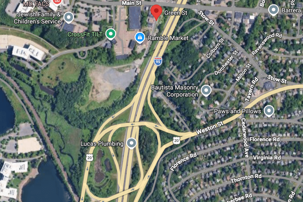
This corridor will connect the Rail Trail and, McCarthy said, is the first step toward building an improved Route 117 bridge over I-95. Waltham Housing Director Collette Casey-Brenner said part of this grant money was coming from the state housing fund because the new road will facilitate future housing development in the area.
The project will be managed by the construction site’s owners and real estate companies BXP Inc. and 1265 Main Street LLC. McCarthy said the city will have to apply to the state’s Community One Stop For Growth program next year for additional grant money to receive the full $15 million promised for the project, but that the landowners plan to match the state’s funding for the road’s construction. Waltham should not have to contribute any additional money, she said.
She added that the project is being realized after “more than 20” years of work and projected it will be completed by September 2028.
The Finance Committee voted unanimously to accept the grants.
Additionally, the City Council’s committees:
- Asked the Law Department to draft new zoning language lowering affordability requirements for housing development. The committee voted to require developers to create fewer affordable units, especially in smaller buildings, and make a portion of those units affordable to residents making 60% of the area median income instead of 50%. Some councilors expressed interest in keeping affordability requirements slightly higher and reducing parking space minimums, which advocates have cited as a major deterrent to housing development, but the committee decided parking issues could be better addressed through ongoing zoning reform. (Ordinances & Rules)
- Appointed former Councilor-at-Large Kathy McMenimen to a position as an associate member of the Zoning Board of Appeals and former police officer John J. O’Connor, III as director of veterans’ services and assistant to the License Commission. (Committee of the Whole)
- Approved a $940,000 loan to design a new indoor pool in the Howe Building of the former Fernald State School. (Long-Term Debt and Capital Planning)
- Approved a midyear raise for a current junior city accountant who is taking on additional work while the department attempts to fill a long-vacant position. (Finance)
- Approved the special permit application by TTGROUP WALLEX, INC at 864 Lexington St. to franchise a New Jersey Mike’s location. Despite initial concerns about parking availability and trash removal, the petitioner accepted all conditions of approval on their initial application. (Ordinances & Rules)
- Heard from WPS Superintendent Marisa Mendonsa on the potential effects of the new zoning overlay districts on Waltham elementary schools. (Ordinances & Rules)
- Heard updates on petitions to repave private ways in the city. Assistant City Solicitor Michelle Learned provided new copies of petitions for Samoset Lane and Blossom Street/Pine Hill Circle to redistribute to homeowners because of errors in the original petitions. She also presented updated timelines for successful petitions, projecting that some would return to committee in the spring. (Public Works and Public Safety)
- Reallocated unused money from the Public Works Department to water and sewer projects to cover unexpected costs surrounding an inspector’s resignation and pump station issues. (Finance)
- Voted to transfer the former Phineas Lawrence Elementary School property to the Recreation Department for the purpose of constructing a new municipal hockey rink. (Committee of the Whole)
- Voted to allocate funds that ride-sharing companies have reimbursed to Waltham to resurface roads and sidewalks along Seminole Avenue and Hardy Pond Road. (Finance)
- Voted to purchase a new zamboni to resurface the Veterans’ Memorial Skating Rink. (Finance)
Authors


Comments (3)
Comments are closed.

Thank you for this article. I have a question, what does the red line drawn on Jones Road on the map signify? Should it instead be along Green Street as follows, except, not including Main Street? https://masstrailtracker.com/map?segment=256
Thank you.
The wrong map was posted with this story. Thanks for noticing. We have replaced it with a map showing the Rte. 20 interchange.
Thank you!